Enregistrez gratuitement cette image
en 800 pixels pour usage maquette
(click droit, Enregistrer l'image sous...)
|
|
Réf : V01800
Thème :
Terre dans l'espace (419 images)
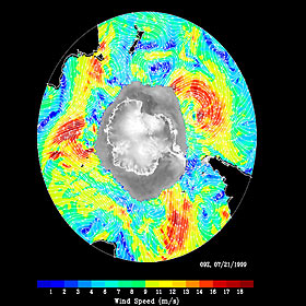
Titre : SeaWinds Wind-Ice Interaction
Description : (La description de cette image n'existe qu'en anglais)
The figure demonstrates of the capability of the instrument on NASA's satellite in monitoring both sea ice and ocean surface wind, thus helping to further our knowledge in wind-ice interaction and its effect on climate change. The gray-scale image of normalized radar back scatter shows various kinds of ice in Antarctica. The land mass is outlined in black. The gray area outside the land mass is occupied by sea ice. Outside of the ice, white streamlines representing wind direction are overlaid onto the color image of wind speed distribution. The map (including both ice and wind) is produced from one day, July 21, 1999, of QuikScat interim observations. With its all-weather observing capability, the satellite provides continuous monitoring of ice edge and tracking of icebergs, and describes the morphology of both glacier ice and sea ice.
|
|

